Showing 40 items matching river street whittlesea
-
 Whittlesea Historical Society Inc.
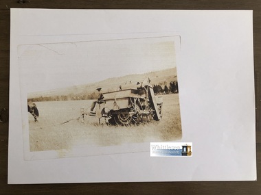
Photocopy of photograph, Harvesting Wheat, Gibson's, River Street, Whittlesea, unknown
... Harvesting Wheat, Gibson's, River Street, Whittlesea...river street whittlesea..., River Street, Whittlesea..., Gibson's, River Street, Whittlesea Photocopy of sepia photograph ...Photocopies of old photos from John McPhee of Conron Grange, Whittlesea. Conron Grange was established by Robert and Mary Ann Armstrong in 1855 as part of the Wills Estate, they were tenant farmers to Wills, Mary Ann named the first house Conron Grange meaning "Pretty place with full barns". Robert was killed falling from a horse in 1863 leaving Mary-Ann with children aged 7, 5, 3, 2, and a baby aged 8 weeks. Mary Ann married James Johnston in 1867. Conron Grange remained in the Johnston family until 1938 when John McPhee's parents bought it, it then remained in the McPhee name until John sold it in 2003. Whittlesea Pioneer families, Coulthard and AndrewPhotocopy of sepia photograph, A4 page, (12 of 20)Typed note attached to the rear: Harvesting Wheat, Gibson's, River Street, Whittleseajohn mcphee, conron grange, whittlesea, mary ann armstrong, james johnston, wills estate, farming, horse, whittlesea pioneers, gibson family, river street whittlesea, harvesting wheat -
 Whittlesea Historical Society Inc.
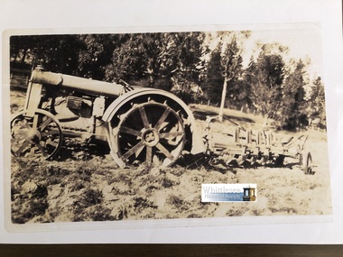
Photocopy of photograph, Ford tractor and plough Gibson's River Street Whittlesea, unknown
... Ford tractor and plough Gibson's River Street Whittlesea...river street whittlesea... Gibson's River Street Whittlesea... Gibson's River Street Whittlesea Photocopy of sepia photograph, A4 ...Photocopies of old photos from John McPhee of Conron Grange, Whittlesea. Conron Grange was established by Robert and Mary Ann Armstrong in 1855 as part of the Wills Estate, they were tenant farmers to Wills, Mary Ann named the first house Conron Grange meaning "Pretty place with full barns". Robert was killed falling from a horse in 1863 leaving Mary-Ann with children aged 7, 5, 3, 2, and a baby aged 8 weeks. Mary Ann married James Johnston in 1867. Conron Grange remained in the Johnston family until 1938 when John McPhee's parents bought it, it then remained in the McPhee name until John sold it in 2003. Photocopy of sepia photograph, A4 page, (5 of 20)Typed note attached to the rear, Ford tractor and plough Gibson's River Street Whittleseajohn mcphee, conron grange, whittlesea, mary ann armstrong, james johnston, wills estate, farming, ploughing, river street whittlesea, ford tractor, plough, gibson -
 Whittlesea Historical Society Inc.
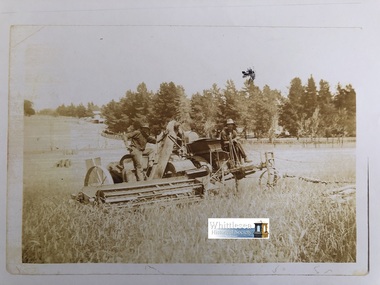
Photocopy of photograph, Harvesting Wheat, Gibson's, River Street, Whittlesea, unknown
... Harvesting Wheat, Gibson's, River Street, Whittlesea...Note on the rear, Harvesting Wheat Gibsons River Street..., Gibson's, River Street, Whittlesea Photocopy of sepia photograph ...Photocopies of old photos from John McPhee of Conron Grange, Whittlesea. Conron Grange was established by Robert and Mary Ann Armstrong in 1855 as part of the Wills Estate, they were tenant farmers to Wills, Mary Ann named the first house Conron Grange meaning "Pretty place with full barns". Robert was killed falling from a horse in 1863 leaving Mary-Ann with children aged 7, 5, 3, 2, and a baby aged 8 weeks. Mary Ann married James Johnston in 1867. Conron Grange remained in the Johnston family until 1938 when John McPhee's parents bought it, it then remained in the McPhee name until John sold it in 2003. Photocopy of sepia photograph, A4 page, (2 of 20)Note on the rear, Harvesting Wheat Gibsons River Street Whittleseajohn mcphee, conron grange, whittlesea, mary ann armstrong, james johnston, wills estate, river street, gibson, harvesting wheat, farming -
 Whittlesea Historical Society Inc.
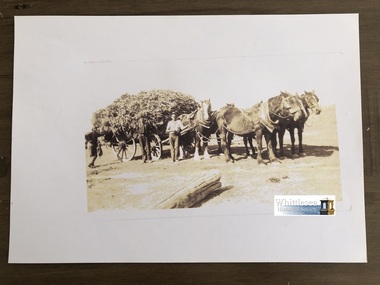
Photocopy of photograph, Load of maize, Gibson's, River Street, Whittlesea, 1977
... Load of maize, Gibson's, River Street, Whittlesea...river street whittlesea..., River Street, Whittlesea Photocopy of sepia photograph, A4 page ...Photocopies of old photos from John McPhee of Conron Grange, Whittlesea. Conron Grange was established by Robert and Mary Ann Armstrong in 1855 as part of the Wills Estate, they were tenant farmers to Wills, Mary Ann named the first house Conron Grange meaning "Pretty place with full barns". Robert was killed falling from a horse in 1863 leaving Mary-Ann with children aged 7, 5, 3, 2, and a baby aged 8 weeks. Mary Ann married James Johnston in 1867. Conron Grange remained in the Johnston family until 1938 when John McPhee's parents bought it, it then remained in the McPhee name until John sold it in 2003. Whittlesea Pioneer families, McPheePhotocopy of sepia photograph, A4 page, (14 of 20)Typed note attached to the rear: Load of Maize Gibsons River Streetjohn mcphee, conron grange, whittlesea, mary ann armstrong, james johnston, wills estate, farming, whittlesea pioneers, gibson family, gibson, river street whittlesea, maize, horse, horse and wagon -
 Greensborough Historical Society
Map, Melbourne and Metropolitan Board of Works. Survey Division, MMBW, Yarra 2500 / 12.22. Watsonia North, 1978_03
Melbourne and Metropolitan Board of Works. Yarra 2500 [base map]. 12-22, Parishes of Keelbundora 2856, Municipalities of Whittlesea 239 and Diamond Valley 257. Shows street names, easement sizes, lot numbers, lodged plan numbers, names of prominent features, contour values, creek or river names. Watsonia Railway Station and environs. Prominent streets: Edmund Rice Parade and Macorna Street. Includes Christian Brothers Edmund Rice College and Janefield Special School sites and "proposed future freeway" (now Metropolitan Ring Road).MMBW Map in 1:2500 [scale] series. Cream parchment with green tape reinforcing on edges and punched holes on left edge.mmbw, melbourne and metropolitan board of works, shire of diamond valley, watsonia - maps, bundoora - maps -
 Greensborough Historical Society
Map, Melbourne and Metropolitan Board of Works. Survey Division, MMBW, Yarra 2500 / 12.24. Plenty and Blue Lake, 1977_10
Melbourne and Metropolitan Board of Works. Yarra 2500 [base map]. 12-24, Municipalities of Whittlesea 239 and Diamond Valley 257. Shows street names, easement sizes, lot numbers, lodged plan numbers, names of prominent features, contour values, creek or river names. Watsonia Railway Station and environs. Prominent streets: Memorial Drive. Includes Plenty River and Blue Lake in the Plenty Gorge.MMBW Map in 1:2500 [scale] series. Cream parchment with green tape reinforcing on edges and punched holes on left edge.mmbw, melbourne and metropolitan board of works, shire of diamond valley, plenty - maps, blue lake -
 Greensborough Historical Society
Map, Melbourne and Metropolitan Board of Works. Survey Division, MMBW, Yarra 2500 / 12.23. Janefield and Kangaroo Point, 1977_10
Melbourne and Metropolitan Board of Works. Yarra 2500 [base map] 12-23, Municipalities of Whittlesea 239 and Diamond Valley 257. No streets marked on this map. Includes Plenty River, Kangaroo Point, Janefield Colony and Janefield Reserve.MMBW Map in 1:2500 [scale] series. Cream parchment with green tape reinforcing on edges and punched holes on left edge.mmbw, melbourne and metropolitan board of works, shire of diamond valley, plenty - maps -
 Greensborough Historical Society
Map, Melbourne and Metropolitan Board of Works. Survey Division, MMBW, Yarra 2500 / 13.22. Greensborough, Apollo Parkways, 1979_06
Melbourne and Metropolitan Board of Works. Yarra 2500 [base map] 13-22. Greensborough, Apollo Parkways. Parishes of Nillumbik 3310 and Keelbundora 2856. Municipalities of Diamond Valley 257 and Whittlesea 239. Prominent streets include: Plenty River Drive, Diamond Creek Road and Civic Drive. Includes Diamond Valley Civi Centre, Churinga, Janefield Colony Reserve and "proposed freeway" now Greensborough Highway (Bypass)MMBW Map in 1:2500 [scale] series. Cream parchment with green tape reinforcing on edges and punched holes on left edge.mmbw, melbourne and metropolitan board of works, shire of diamond valley, greensborough - maps, apollo parkways - maps -
 Greensborough Historical Society
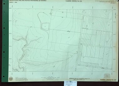
Map, Melbourne and Metropolitan Board of Works. Survey Division, MMBW, Yarra 2500 / 14.28. Yarrambat Park, 1977_09
Melbourne and Metropolitan Board of Works. Yarra 2500 [base map] 14.28. Yarrambat Park. Municipalities of Diamond Valley 257 and Whittlesea 239. Prominent streets include: Bannons Road and Yan Yean Road. Features include the Plenty River.MMBW Map in 1:2500 [scale] series. Cream parchment with green tape reinforcing on edges and punched holes on left edge.mmbw, melbourne and metropolitan board of works, shire of diamond valley, whttlesea, yarrambat - maps -
 Greensborough Historical Society
Map, Melbourne and Metropolitan Board of Works. Survey Division, MMBW, Yarra 2500 / 13.24. Plenty, Memorial Drive, 1979_03
Melbourne and Metropolitan Board of Works. Yarra 2500 [base map] 13-24. Plenty, Memorial Drive. Parish of Morang 3183. Municipalities of Diamond Valley 257 and Whittlesea 239. Prominent streets include: Oatland Road, River Avenue and Memorial Drive. Includes Plenty River and SEC Transmission easement.MMBW Map in 1:2500 [scale] series. Cream parchment with green tape reinforcing on edges and punched holes on left edge.mmbw, melbourne and metropolitan board of works, shire of diamond valley, plenty - maps -
 Greensborough Historical Society
Map, Melbourne and Metropolitan Board of Works. Survey Division, MMBW, Yarra 2500 / 13.26. Yarrambat, Worns Lane, 1978_02
Melbourne and Metropolitan Board of Works. Yarra 2500 [base map] 13.26. Yarrambat, Worns Lane. Municipalities of Diamond Valley 257 and Whittlesea 239. Prominent streets include: Worns Road, North Oatlands Road and Licola Street. Features include Plenty River.MMBW Map in 1:2500 [scale] series. Cream parchment with green tape reinforcing on edges and punched holes on left edge.mmbw, melbourne and metropolitan board of works, shire of diamond valley, whttlesea, yarrambat - maps -
 Greensborough Historical Society
Map, Melbourne and Metropolitan Board of Works. Survey Division, MMBW, Yarra 2500 / 13.23. Plenty, Middle Gorge, 1978_04
Melbourne and Metropolitan Board of Works. Yarra 2500 [base map] 13-23. Plenty / Middle Gorge. Parish of Morang 3183. Municipalities of Diamond Valley 257 and Whittlesea 239. Prominent streets include: Gorge Road, Kurrak Road and Browns Lane. Features include the Plenty River and Plenty Gorge Park.MMBW Map in 1:2500 [scale] series. Cream parchment with green tape reinforcing on edges and punched holes on left edge.mmbw, melbourne and metropolitan board of works, shire of diamond valley, plenty - maps, plenty gorge park -
 Orbost & District Historical Society
black and white photograph, late 19th century - early 20th century
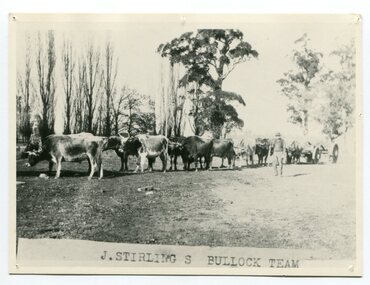
Aged 19 James Stirling arrived in Melbourne on January 26, 1842 with his family - parents, three sisters and two brothers. James Stirling moved around a lot to Whittlesea, Ballarat goldfields, Cunninghame, (now Lakes Entrance), then to the Old Station about 36 miles to the east along the coast near the mouth of the Snowy River and for a time settled there with his wife also from Wigton, Scotland, and their family four sons two daughters (James, John, William, George, Margaret and Polly). The first settler to occupy the Marlo township area was James Stirling around the year 1875. He built a bark hut on the bluff that had two rooms, bark walls, earthen floors and a shingle roof. By 1884, this structure had expanded to a 9 roomed accommodation house and in 1886 became the Marlo Hotel when a liquor license was granted. (more information from “Snowy River Mail”, Wednesday, April 13th 1977: MEMORIES OF MARLO by Mrs Elsbeth Conlon (nee Stirling ) During the 19th century bullock teams were the most effective means of transporting people and goods inland, as the roads were badly made and in poor condition. The better roads were closer to the towns, and the further away from the town, the worse the conditions of the roads. Bullock teams drew heavily laden carts full of provisions, equipment and people from town to town and into the countryside to isolated homes. This item is associated with that era. It is also associated with James Sterling a very early settler of Marlo.A black / white photograph of a bullock team with a man standing beside it.on front - J STIRLING S BULLOCK TEAMstirling-james marlo-history bullock-team transport -
 Eltham District Historical Society Inc
Album - Photograph Album, J.A. McDonald, Bridge and Road Reconstruction Works, Shire of Eltham, 1952-1962
J.A. McDonald produced this record in the course of his responsibilities as Shire Engineer for Eltham Shire Council.Record of various Shire of Eltham infrastructure works undertaken during the period of 1952-1962 involving bridge and road reconstruction projects, sometimes with Eltham Shire Council Project Reference numbers quoted. It was during this period that a number of significant improvements were made to roads and new bridges constructed within the shire that remain in place as of present day (2022). In many situations, the photos provide a tangible visible record of infrastructure that existed throughout the early days of the Shire. The album was put together by or under the direction of the Shire Engineer, J.A. McDonald.a. gillies, alistair knox park, benchmark studies, bend of islands, blease road, box hill state school, box hill teachers college, box hill tip, bridge construction, bridge street bridge, bridge, brisbane street, brougham steet, bulldozer, cecil street, charis pelling, cherry tree road, city of preston, cr. a. brinkkotter, cr. charis pelling, cranes, cromwell street, diamond creek (creek), diamond street, dixons creek bridge, dixon's creek road, drott, eltham leisure centre, eltham north, eltham police station, eltham, eltham-yarra glen road, f. wood, fitzsimons lane bridge, flat rock road, flood damage, floods, floodwater, footpaths and gutters, ford service garage, g. blair, garden hill, glen park bridge, glenauburn road, grand hotel, haldane road, healesville, healesville-yarra glen road, heidelberg-kinglake road, henley road bridge, henley road, hill property, hurstbridge water scheme, hurstbridge, hurstbridge-arthurs creek road, infrastructure, j. jolly, kangaroo ground, kangaroo ground-queenstown road, kangaroo ground-st andrews road, lilydale shire office, long gully bridge, long gully creek, long gully road, long gully, lower plenty bridge, lower plenty footbridge, lower plenty oval, lower plenty road, lower plenty, main road, methodist church, montmorency, mount pleasant road, new holland, old healesville road, opening ceremony, oxley bridge, para road, paul creek bridge, paul creek road, paul krafeznk, pinnacle lane, plaques, plenty river trail, plenty river, presbyterian church, prof donald thomson, pryor street, railway crossing, railway parade, rattray road, reconstruction works, reichelt avenue, research (vic.), research oval, road construction, rymers corner, shire of eltham, shire of whittlesea, silvan road bridge, silver street bridge, silver street, sir dallas brooks, smedley property, st andrews, steels creek, susan street, tarrawarra, tony carberry, uniting church, upper yarra dam, upper yarra reservoir, w.e. wolf, waterfall property, watsons creek, wattletree road bridge, wattletree road, wattletree road bridge, worlingworth, yarra glen, york street, yow yow creek -
 Whittlesea Historical Society Inc.
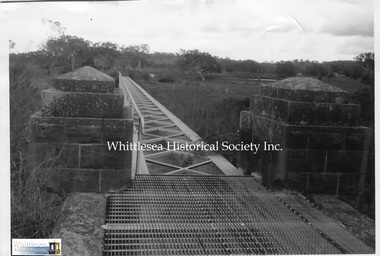
Photograph, Matt Dickinson, The Flume Mernda, 1998
A photograph of the Flume over the Plenty River at Mernda. The flume and iron aqueduct over the Plenty River at Mernda was constructed 1878/79 to replace the 1850's bridge destroyed by floods in 1878. The flume is part of the Yan Yean Water Supply System that originally supplied water to Melbourne. It remained in service until 1960.Listed on The National Trust Heritage Register.Black and white photograph.M. Dickinson 1998 handwritten on the backmernda, flume, aqueduct, mernda flume, plenty river mernda, yan yean water supply system -
 Whittlesea Historical Society Inc.
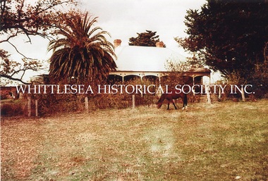
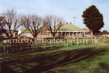
Photograph, Carome, Mernda, c. 1960
3 photographs showing Carome at Mernda dated mid 1960's. CAROME In 1840 Arthur Sergeantson purchased Section 19, Parish of Morang, a total of 842 acres. He named the property `Sergeantson Hall’ but the portion between the Plenty Road and Plenty River soon became known as Carome, the name of a flour mill he established in 1841. In 1843 Sergeantson leased the mill to a miller named Anderson, who operated it until 1850. Anderson was followed by Robert Charles. The present dwelling date back to at least 1850, and possibly earlier. In 1857 Sergeantson’s remaining 411 acres and Carome Mill were purchased by Abraham Willis and William Hardesty, who refurbished and upgraded the mill at the enormous cost of 1,200 Pounds. In 1868 the Mill was destroyed by fire. Willis continued farming at Carome until 1899 when he leased the farm to his son Robert and retired to Carlton. Little of the Mill remains. It was set just downstream from the deep rocky waterhole which formed a natural dam. Local folklore has it that this waterhole was used for water games by the Aborigines. Europeans certainly swim there now, and locals refer to this area as Power's hole, named after the previous owners the Power family. Such a prominent waterhole is likely to have been well known to the Aborigines. (Reference: City of Whittlesea Heritage Study) 3 colour photographs.mernda, carome mernda, bluestone, power family, willis family, abraham willis, isabella willis, carome mill, powers hole -
 Whittlesea Historical Society Inc.
Photograph, Carome, Mernda, 2006
5 photographs showing Carome homestead and property at Mernda dated 2006. 1. Carome homestead. 2. Carome, looking southward down old rail line. 3. Carome homestead. 4. Dairy/feed sheds at Carome. 5. Carome property. CAROME In 1840 Arthur Sergeantson purchased Section 19, Parish of Morang, a total of 842 acres. He named the property `Sergeantson Hall’ but the portion between the Plenty Road and Plenty River soon became known as Carome, the name of a flour mill he established in 1841. In 1843 Sergeantson leased the mill to a miller named Anderson, who operated it until 1850. Anderson was followed by Robert Charles. The present dwelling date back to at least 1850, and possibly earlier. In 1857 Sergeantson’s remaining 411 acres and Carome Mill were purchased by Abraham Willis and William Hardesty, who refurbished and upgraded the mill at the enormous cost of 1,200 Pounds. In 1868 the Mill was destroyed by fire. Willis continued farming at Carome until 1899 when he leased the farm to his son Robert and retired to Carlton. Little of the Mill remains. It was set just downstream from the deep rocky waterhole which formed a natural dam. Local folklore has it that this waterhole was used for water games by the Aborigines. Europeans certainly swim there now, and locals refer to this area as Power's hole, named after the previous owners the Power family. Such a prominent waterhole is likely to have been well known to the Aborigines. (Reference: City of Whittlesea Heritage Study) 5 colour photographs.Printed on Kodak Royal Digital Papermernda, carome mernda, bluestone, power family, willis family, abraham willis, isabella willis, carome mill, powers hole, william hardesty, arthur sergeantson -
 Whittlesea Historical Society Inc.
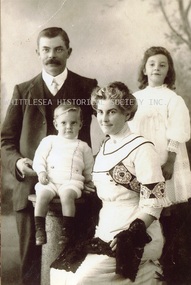
Photograph - Copy, Alfred, Lucy, Florence and Charles Arnold, c.1910
A photograph of Alfred Arnold his wife Lucy (nee Willis) and their children Florence and Charles. Lucy is the daughter of Abraham and Isabella Willis of Carome in Mernda. CAROME In 1840 Arthur Sergeantson purchased Section 19, Parish of Morang, a total of 842 acres. He named the property `Sergeantson Hall’ but the portion between the Plenty Road and Plenty River soon became known as Carome, the name of a flour mill he established in 1841. In 1843 Sergeantson leased the mill to a miller named Anderson, who operated it until 1850. Anderson was followed by Robert Charles. The present dwelling date back to at least 1850, and possibly earlier. In 1857 Sergeantson’s remaining 411 acres and Carome Mill were purchased by Abraham Willis and William Hardesty, who refurbished and upgraded the mill at the enormous cost of 1,200 Pounds. In 1868 the Mill was destroyed by fire. Willis continued farming at Carome until 1899 when he leased the farm to his son Robert and retired to Carlton. Little of the Mill remains. It was set just downstream from the deep rocky waterhole which formed a natural dam. Local folklore has it that this waterhole was used for water games by the Aborigines. Europeans certainly swim there now, and locals refer to this area as Power's hole, named after the previous owners the Power family. Such a prominent waterhole is likely to have been well known to the Aborigines. (Reference: City of Whittlesea Heritage Study) Copy of black and white photograph.Printed on Kodak Professional Endura Papermernda, carome mernda, bluestone, power family, willis family, abraham willis, isabella willis, carome mill, powers hole, william hardesty, arthur sergeantson, alfred arnold, lucy willis, lucy arnold, florence arnold, charles arnold -
 Whittlesea Historical Society Inc.
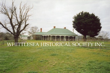
Photograph, Carome Homestead, Mernda, 1972
A photograph showing Carome homestead in Mernda dated 1972. CAROME In 1840 Arthur Sergeantson purchased Section 19, Parish of Morang, a total of 842 acres. He named the property `Sergeantson Hall’ but the portion between the Plenty Road and Plenty River soon became known as Carome, the name of a flour mill he established in 1841. In 1843 Sergeantson leased the mill to a miller named Anderson, who operated it until 1850. Anderson was followed by Robert Charles. The present dwelling date back to at least 1850, and possibly earlier. In 1857 Sergeantson’s remaining 411 acres and Carome Mill were purchased by Abraham Willis and William Hardesty, who refurbished and upgraded the mill at the enormous cost of 1,200 Pounds. In 1868 the Mill was destroyed by fire. Willis continued farming at Carome until 1899 when he leased the farm to his son Robert and retired to Carlton. Little of the Mill remains. It was set just downstream from the deep rocky waterhole which formed a natural dam. Local folklore has it that this waterhole was used for water games by the Aborigines. Europeans certainly swim there now, and locals refer to this area as Power's hole, named after the previous owners the Power family. Such a prominent waterhole is likely to have been well known to the Aborigines. (Reference: City of Whittlesea Heritage Study) Colour photograph.Printed on Kodak Professional Endura Paper.mernda, carome mernda, bluestone, power family, willis family, abraham willis, isabella willis, carome mill, powers hole, william hardesty, arthur sergeantson -
 Whittlesea Historical Society Inc.
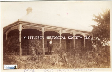
Photograph - Copy, Carome Homestead, Mernda, 1932
A photograph of a man in front of Carome Homestead, 1932. CAROME In 1840 Arthur Sergeantson purchased Section 19, Parish of Morang, a total of 842 acres. He named the property `Sergeantson Hall’ but the portion between the Plenty Road and Plenty River soon became known as Carome, the name of a flour mill he established in 1841. In 1843 Sergeantson leased the mill to a miller named Anderson, who operated it until 1850. Anderson was followed by Robert Charles. The present dwelling date back to at least 1850, and possibly earlier. In 1857 Sergeantson’s remaining 411 acres and Carome Mill were purchased by Abraham Willis and William Hardesty, who refurbished and upgraded the mill at the enormous cost of 1,200 Pounds. In 1868 the Mill was destroyed by fire. Willis continued farming at Carome until 1899 when he leased the farm to his son Robert and retired to Carlton. Little of the Mill remains. It was set just downstream from the deep rocky waterhole which formed a natural dam. Local folklore has it that this waterhole was used for water games by the Aborigines. Europeans certainly swim there now, and locals refer to this area as Power's hole, named after the previous owners the Power family. Such a prominent waterhole is likely to have been well known to the Aborigines. (Reference: City of Whittlesea Heritage Study) Copy of a black and white photograph.Handwritten on the back: Carome Mernda 1932mernda, carome mernda, bluestone, power family, willis family, abraham willis, isabella willis, carome mill, powers hole, william hardesty, arthur sergeantson -
 Whittlesea Historical Society Inc.
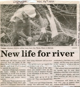
Newspaper - Newspaper Clipping, Whittlesea Post, New life for river, 24 Nov 1999
Workers remove more than 100 willow trees from the banks of the Plenty River in Mernda.Newsprint with black and white image.mernda, plenty river mernda, willow tree -
 Whittlesea Historical Society Inc.
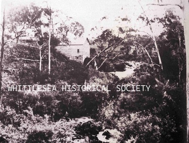
Photograph - Copy, Carome Mill
A copy of a photograph of Willis Flour Mill on the banks of the Plenty River at Carome Homestead in Mernda, 1858.Willis family pioneer of MerndaA4 copy of black and white photograph with velcro tabs on back used for display.Handwritten on the front: "Carome" Willis mill near the Plenty River (1858) One of the earliest known photos take in the City of Whittlesea (La Trobe collections, State Library of Victoria.)mernda, flour mill, carome flour mill, willis flour mill, carome mill, willis mill, plenty river mernda, 1858, willis family -
 Whittlesea Historical Society Inc.
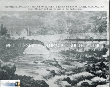
Photograph - Copy, Repairing Aqueduct Bridge over Plenty River by Searchlight, Morang, 1878, c.1878
Repairing the Yan Yean Aqueduct over the Plenty River at Morang (now Mernda), after the great flood in 1878, Moses Thomas's flour mill can be seen in the background. Moses Thomas pioneer of Mernda.A4 black and white copy of a sketchmernda state school, moses thomas, thomas family, mayfield flour mill, mayfield mill, yan yean aqueduct, yan yean flume, plenty river, flood 1878 -
 Whittlesea Historical Society Inc.
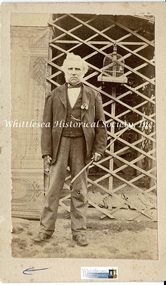
Photograph - Original photograph, Dr. William Ronald, c.1870's
Dr. William Ronald standing at the door of his house at "Williambrook". Pioneer settler, J.P., and Whittlesea's resident doctor, Dr. William Ronald (1808-1882) born Scotland, and Eliza O'Meara (1810-1893) born Ireland, married 1831, arrived Plenty 1842. Dr. Ronald donated the site for the Yan Yean Cemetery in 1854 and became one of the first trustees. He built his second home, "Williambrook", beside the Plenty River, located behind Kelvin Thomas' home on Plenty Road. He was poor, but well respected by the locals.Original sepia photographDr. Ronald/ At door of home/ on River behind Vic/ Thomas./ 24. The Plenty/ 4 x 2dr. william ronald, whittlesea, williambrook, yan yean cemetery trustee, eliza o'meara -
 Whittlesea Historical Society Inc.
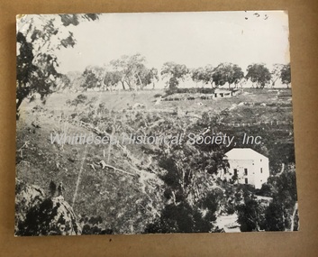
Photograph, Coulstock's Mill on the Plenty River near Bundoora
This photograph forms part of a collection of photographs gathered by the Whittlesea Historical Society for their project book, "Historic Views of the City of Whittlesea" by Robert Wuchatsch and Gwen Hawke, as part of Australia's Bicentennial Celebrations in 1988. The collection contains over 200 historic photographs covering all aspects of early life in the area now embraced by the City of Whittlesea.Black and white print mounted on a foam backing for display.Inscribed in blue ink on back of photo [Coulstock's Mill on the Plenty River near Bundoora]historic views of the city of whittlesea, janefield, coulstock's mill, flour mill -
 Whittlesea Historical Society Inc.
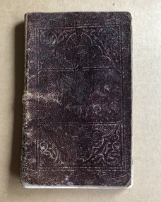
Book - Work Book, Personal Work Book of William Lockwood used c.1865, c.1865
The work book was used by William Lockwood to record estimates for proposed works within the Shire of Whittlesea. Mentions Prince of Wales Hotel, Glenvale Common School and Bridge over Plenty River. William Lockwood – First Engineer of Whittlesea. William Henry Lockwood was born in Glossop, Derbyshire c.1832. He migrated to Victoria on the first voyage of the Marco Polo in 1853 and married Naomi Bullock in St. Peter’s Church of England Melbourne on 27th December 1856. They had nine children, four of whom died in infancy and were buried in Yan Yean Cemetery. The family lived in Whittlesea in a two-storey home, which faced Church Street. William was a talented engineer and architect. He commenced work as a contractor and surveyor for the Whittlesea Roads’ Board and became Whittlesea Shire Engineer in the 1870’s. He continued in this role until his death in 1912. During his time as engineer he built many buildings, bridges and roads within the Whittlesea Shire including the Whittlesea Courthouse and the Whittlesea State School. On two of our local bridges, which were constructed during 1901, he was the engineer and builder. These are the Darebin Creek Bridge in Bridge Inn Road, Wollert and the Barber’s Creek Bridge in Plenty Road, Yan Yean. Both bridges are no longer in use. The Bridges are Monier reinforced concrete with bluestone abutments and were designed by Sir John Monash. In addition to his engineering work he was Postmaster and Registrar of Births, Deaths and Marriages for Whittlesea. He was appointed as inaugural treasurer of the Shire of Whittlesea in January 1875 and was actively involved in other community organisations. In the last few years of his life he continued working in spite of ill health. In her diary, his wife Naomi documented his last months. One entry reads, “16 Oct 1911 My husband in his office with Shire Secretary comparing books for audit”. After William’s death his daughter, Martha Hannah became Postmistress and another daughter, Wilhelmina Naomi Priscilla became Registrar for Whittlesea. A third daughter Sister Mary Emma was involved in charity work throughout Victoria working for the children of Sutherland Homes. She also appears to have acted as Registrar at Whittlesea after her sister Wilhelmina died in 1923. William Henry Lockwood died on January 12th 1912. The local community held him in high esteem for his contribution to the Whittlesea area. His wife Naomi died 22nd December 1912. The Lockwood family grave can be seen at Yan Yean Cemetery. Brown, leather covered pocket sized book.william lockwood, whittlesea, william henry lockwood, work book, plenty river, glenvale school, prince of wales hotel whittlesea -
 Whittlesea Historical Society Inc.
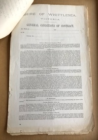
Document - Contract, Contract No.7, Shire of Whittlesea, Victoria. Plenty Main Road, 10 Dec 1888
Specifications for supplying 300 Cubic Yards of Metal on the side of the Main Plenty Road, between Yan Yean Road and the Plenty River Bridge, Whittlesea.3 sheets of paper held together with a brass split pin, includes General Conditions of ContractContract signed by William Henry Lockwood, Engineer, with Bryan McSweeney. Dated 10 December 1888.contract, william lockwood, main plenty road, whittlesea, yan yean road, bryan mcsweeney -
 Whittlesea Historical Society Inc.
Photograph, Bridge over Plenty River at South Morang
Bridge over Plenty River at South Morang.B&W Copy of photograph printBridge over Plenty River at South Morangbridge, south morang, plenty river -
 Whittlesea Historical Society Inc.
Photocopy of Life Member Badge, Whittlesea Agricultural Society Annual Show: Charles W Andrew Esq, 1950
Photocopies of old photos from John McPhee of Conron Grange, Whittlesea. Photocopy on glossy paper of blue coloured Life Member badge, A4 page, (1 of 20)Inscribed Whittlesea Agricultural Society Annual Show Saturday, 4th November, 1950 Life Member. President: E. Payne. Sec. - Treas.: L. L. Braund. 703. Charles W Andrew Esq.john mcphee, conron grange, whittlesea, james johnston, wills estate, river street, gibson, harvesting wheat, farming, mary ann armstrong, robert armstrong, whittlesea agricultural society, life member, charles w andrew -
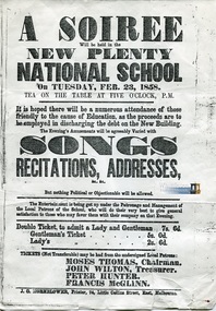 Whittlesea Historical Society Inc.
Document - Flyer, A Soiree, New Plenty National School
Mernda Primary School 488 was established in 1853, under the name Plenty National School. The first classes were held in a barn at Carome Homestead, located on the banks of the Plenty River. By October 1853 a new schoolhouse was erected on 2 acres of land donated by Moses Thomas, on a site further south along Plenty Road. In 1858, a new one roomed wooden schoolhouse was erected in bluestone foundations at a cost of 200 pounds. The school's name was changed to 488 Morang and changed again in 1913 to 488 Mernda. 1 p., A4, copy.J. G. Hornblower, Printer, 74 Little Collins Street, East Melbourne.plenty national school, mernda primary school, 488 mernda, 488 morang, 488 plenty, moses thomas, john wilton, peter hunter, francis mcglinn